As you approach the village from the east there was a small row of 4 or 5 cottages immediately after Seabegs Wood or The Doctor’s Wood as it was called locally. The site is now used to store road materials. This was called Venezia and belonged to the brickworks. Further on is Dalnair Cottage still standing at the side of the pend under the canal and was owned by Stein’s This was occupied by the Reed family. At the other side of the pend on the canal side were two adjoining cottages which were demolished when the line of the road was changed. These were also owned by Stein’s Next is Underwood Cottage again owned by Stein’s, which was occupied by the McLeods for a number of years and still stands. At the foot of the hill is Underwood Lock on the canal, now an Indian Restaurant but was once occupied by the Lauries. Mr. Laurie was the lockkeeper and his house was attached to the stables where the horses were kept overnight when barges were hauled by them on the journey from Grangemouth to Glasgow.
At the top of the hill on the south side is Muirhead Cottage which was once a farm but is now only a villa. It was occupied by the Reid family and later by Jimmy Buchanan and his family and on the other side of the road is Lockpark Cottage which was occupied by the Millar family. Mr. Millar was a butcher and his father owned Muirhead Cottage when it was a farm. Muirhead cottage was owned by Steins.
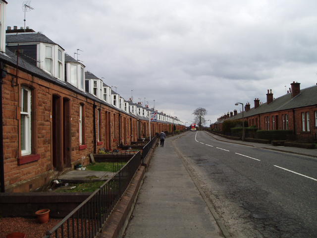
We have now reached the east end of Allandale but before the rows of cottages was the White House, also long gone occupied by Sam Reid and his family and later by the Johnstons. Sam kept hens and bees in his large garden and I believe part of his job in the brickwork pit was to deliver explosives from the storehouse behind Dundas Cottages to the pit each day. We are now in the main part of the village, the two neat rows of cottages faced with red Dumfries sandstone and divided every ten houses with a passage or “close”. The houses on the railway side were the even numbers and the canal side the odd numbers. The eight blocks of houses all differed in some way. The first block to be built was at the west end of the south side. These consisted of a living room which for some reason was called “the kitchen”, a bedroom, the kitchen which was called “the scullery” and outside toilet. All the other houses in Allandale had inside toilets. There were front and back doors to each house. The bath for all the houses on the south side was in the scullery and there was no privacy. These houses also had an indoor coal cellar. Except for four end houses in the middle two blocks which had their own landing, all the others had a shared landing with the house next door both at the front and the back. All the houses had a small front garden but nothing at the back except a shared drying green During wartime there was the “dig for victory” campaign and everyone was encouraged to dig an allotment or ‘plot’ as they were called. Some of these utilised the ground between the drying greens and the railway but others were dug in a field at the west end next to the canal. Between the houses and the drying greens was a dirt road and at the side of the greens, which contrary to their name did not have any grass, were two sets of swings for the children. There also was a maypole but I can’t remember seeing any ropes attached to it. At the west end of the south side was a small playpark where football was played but this was slightly difficult owing to the almost 30 degree slope.
On the north side were another four blocks of houses which were the last to be built. These were roughly all of a similar layout. There was a living room, bedroom, kitchen and bathroom on the ground floor and a bedroom upstairs. Except for all the end houses in each block which had their own landing, these houses also shared a landing but they shared the front landing with a different neighbour. They also had a dirt road next to the houses then drying greens. As the ground on which Allandale was built sloped from the south down to the canal in the north, the area was levelled off using ashes, etc. from the brickworks and the part next to the canal had a steep drop. In fact, the rubbish from the houses was still being collected by horse and cart up until the 1940s and dumped over the bing next to the canal. This was supplemented by waste from the brickworks.
We continue our tour from the west end of the village up the slight incline to the post office and sweet shop at the top of the hill. This shop is still in existence. The shop was locally known as ‘the dairy’ for some reason but, as far as I can remember, no milk was ever sold there. The shop was run by Mrs. Dunsmore. Her husband, Adam, had a job in the brickworks and her son, also Adam, was employed there also. Later, Mrs. Dunsmore passed the shop on to her sister, Kate Bell, after the war and she ran it with a friend from the army. The Dairy had a house attached which was occupied by the Dunsmores. Above the dairy was two houses, one occupied by Bill ‘Whistler’ Millar and his family and the other by Willie Weir and family. Incidently, I believe Bill Millar was the only person in Allandale who owned a car during the war but it lay in the garage all during this time. The whole building was owned by a Mr. Tom Scott and was sold to William Stewart when he took over the running of the shop and post office.Further on about a 50 yards westwards, was the other retail establishment, namely the Co-op or as it was called locally, ’the store’.This was a branch of the Longcroft Co-operative Society. More about it later. Above the store were two houses, one occupied by the Jimmy Burnett and family and the other by Jessie Climie and her mother. Jessie was an accomplished violinist, she played for various local orchestras and taught the violin and the piano. Your tuition competed against the distracting sounds of your pals playing football in the adjacent football field.
On the other side of the road from the store, a road went off under the railway bridge then forked again with one road going up the hill to the east entrance to the brickworks and the other going of to the east towards Woodend. The first house on this road was a railway house occupied by the Stirling family who worked on the railway. Then the road turned south up past the entrance to Strang’s farm, or more correctly, North Woodend farm.The farm was run by Mrs. Black whose maiden name was Strang. Her husband was a businessman in Glasgow and their two sons, Hamish and Melville, had other jobs too although they worked on the farm outside working hours. The farm was a source of milk for the village but you had to collect it from the farm. Further on up this road was a row of cottages which might have belonged to the farm but one of them was occupied by a shoe repairer called Swannie and the other by Bob Hamilton and family . Then over the other railway bridge at the LNER railway and we reach Woodend, which has now vanished. Mr. Tom Scott who I mentioned before as owning the shop also owned this building which had about ten houses plus South Woodend farm and the Thorn . At the south side of the LNER railway were two adjoining cottages occupied by a Miss Towers and Paddy McRae, both elderly people. Up the hill from Woodend is South Woodend farm which was occupied by Bill Salmond and family, Betsy, Jean, Bill and Harry. Bill sold milk round the village at one time from churns on the back of his cart. This farm is now occupied by Bill’s daughter, Jean and her husband, Willie Dunsmore. There is a house at the other side of the road, called “The Thorn”. It really was two houses , the main house and a smaller house. The house was occupied at one time by Tom Scott and then by Adam Irons and family. Willie and Jean Dunsmore now live in the Thorn. The road continues on up the hill to more farms.
Back down on the main road, next to the store was the football field and changing hut then further along was the bowling green which also belonged to the brickworks and was called the John G. Stein Bowling Club. The bowling clubhouse was host to a variety of events which will be told later. Another hundred yards and we reach Dundas Cottages, twelve houses which were occupied by office and managerial staff of the brickworks. Opposite Dundas was the west entrance to the brickworks under the railway bridge. Dundas was named after the family name of the Earl of Zetland. A hundred yards further west was Castlecary School which was an alternative to Greenhill School for the children of Allandale for about the first four years of their education. There was only one teacher at the school. Opposite the school was the site of the Roman Fort although there is not much to see as most of the stone was used in the building of the Forth and Clyde Canal but artifacts from the site can be seen in Dollar Park, Falkirk and in Edinburgh Museums. The last house on the road belonged to the Purdie family who had a small transport business. Then down the hill and the road met the main Glasgow – Stirling road at Castlecary Viaduct.